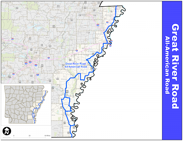

Detailed Driving Directions
Arkansas-Missouri State Line to West Memphis (70 miles)
- The byway starts at the Concrete Arch that spans U.S. Hwy 61 at the state line of Arkansas and Missouri.
- Follow US 61 through Blytheville, Luxora, Osceola, and Wilson to its junction with I-55.
- Turn southeast (right) onto AR 77.
- Follow AR 77 through Marion to its intersection with US 70 in West Memphis.
First Spur (13 miles)
- Drive east on U.S. Hwy 70/E Broadway to I-55.
- Continue east on I-55 to the state line of Arkansas and Tennessee west of Memphis, TN.\Return to the junction of AR 77/N Missouri St and U.S. Hwy 70/E Broadway in West Memphis.
West Memphis to Elaine (104 miles)
- Drive west on US 70/W Broadway to AR 147.
- Turn south (left) on AR 147 to AR 38 near Horseshoe Lake.
- Turn west (right) on AR 38 and follow it into Hughes.
- In Hughes, turn southwest on US 79/Broadway St.
- Continue on US 79 towards Marianna.
- In Marianna, turn east (left) onto AR 1/W Chestnut St.
- Turn south (right) onto S Poplar St., then east (left) on AR 44/Martin Luther King Dr.
- Follow AR 44 to Bear Creek Lake, and turn south (right) onto CR 239.
- Continue south on CR 221
- Turn east (left) onto CR 217.
- At Storm Creek Lake, turn south (left) on CR 215, then south (right) again onto CR Rd. 39.
- Continue on CR 239, which becomes Sterling Road
- Turn left onto the Mississippi River Levee Road, right onto Perry Street, then left on SH 44.
- Continue south, merging briefly onto US 49 before turning south (right) onto AR 44.
- Follow AR 44 into Elaine.
Elaine to Back Gate (71 miles)
- In Elaine, turn west (right) onto AR 20/Main St
- Continue on AR 20 to AR 318 and turn north (right).
- Turn west (left) onto AR 316 and continue to AR 1.
- Drive southwest on AR 1 through St. Charles, De Witt and Gillette.
- Continue on AR 1/US165 to Black Gate.
East Loop to McGehee (43 miles)
- From Back Gate, drive east on AR 1 to AR 4.
- Drive east on AR 4 to US 278/US 65 in McGehee.
West Loop to McGehee (27 miles)
- From Back Gate, drive southwest on US 165/AR 54 to US 165/US 65 in Dumas.
- Follow US 165/US 65 south to its intersection with AR 4 in McGehee.
McGehee to Arkansas-Louisiana Border (45 miles)
- Drive south on US 278/US 65 through Lake Village.
- Turn south (right) onto US 65 and continue through Eudora to the Arkansas-Louisiana state border.
Second Spur (18 miles)
- South of Lake Village, continue on US 278/US 82 instead of turning south onto US 65.
- Continue on US 278/US 82 to the Arkansas-Mississippi state border.
- Turn around and return to the junction of US 278/US 82 and US 65.